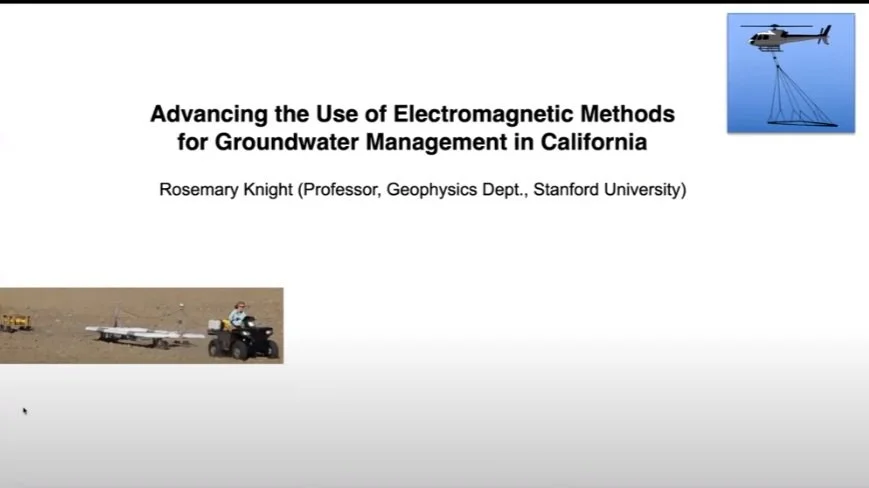
Advancing the Use of Electromagnetic Methods for Groundwater Management in California
Professor Rosemary Knight
Director, GEM Center, Department of Geophysics
Stanford University
Dr. Knight presents innovative ways to use geophysical methods to understand the hydrologic processes occurring in the top kilometer of Earth. Her research experience goes back over 35 years, when she introduced “hydrogeophysics” as a geophysics sub-discipline that has grown dramatically since. Her current focus is the integration of geophysical imaging with remote sensing data for the evaluation and management of groundwater resources using laboratory and field experiments, and computer modeling for the acquisition, processing, and interpretation of geophysical data. She leads a multi-disciplinary team in the development and modeling of relationships between acquired geophysical images and hydrologic properties and processes. Rosemary Knight has a Ph.D. in Geophysics from Stanford University and an M.S. from Queen's University, Kingston, Ontario Canada in Geological Sciences.
Advanced EM Methods I. Introduction
Dr. Knight talks about advancing the use of electromagnetic (EM) imaging methods for groundwater management in California; namely the ground-based towed Transient EM system and the airborne EM method. These non-invasive geophysics methods provide a way to image the subsurface.
Readers are encouraged to take an online course from Stanford Doerr School of sustainability (Harnessing the Power of Geophysical Imaging to Recharge Groundwater).
References:
Rosemary Knight, Finding Water for 10 billion, Climate Change, United Nations, Oct 2019.
Rosemary Knight, Our Freshwater Future, TEDx Stanford, Jun 2015.
Stanford GEM Publications (The Center for Groundwater Evaluation and Management)

Advanced EM Methods II. Sustainable Groundwater Management Act
Dr. Knight describes the geological framework of the San Joaquin Valley, in the southern half of California’s Central Valley. The valley is mostly agricultural, and borders the Sierra Nevada Mountains, which are responsible for much of the surface water that recharges the valley. The subsurface, is fine-grained material with sand and gravel. There are regions where there's a confining unit that separates the upper aquifer from the lower aquifer, but much of the clay is present as dispersed clay interbeds.
Knight then describes the policy framework over the past decade to implement the sustainable Groundwater Management Act, which says that agencies need to manage groundwater in a way that is sustainable; that is, you cannot have any of these undesirable results:
No chronic lowering of water levels
No unreasonable reduction of the amount of groundwater
No unreasonable seawater intrusion
No degradation of water quality
No land subsidence
No depleted interconnected surface water
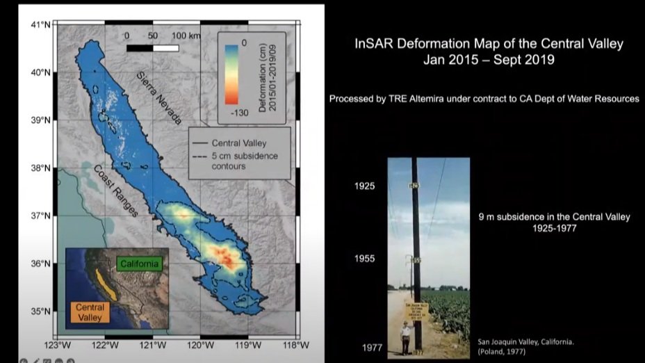
A significant rate of subsidence in the Central Valley of California occurred. The groundwater sinking and saltwater intrusion along the coastline led to a degradation of water quality. Urgent actions are needed to address these critical water issues.
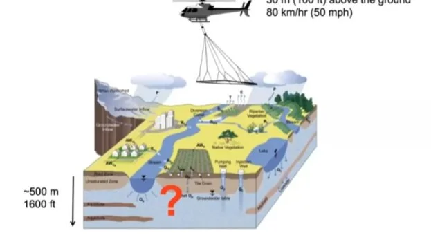
Geophysical methods can be used to implement the Sustainable Groundwater Management Act. This talk focuses on the airborne electromagnetic (AEM) method for imaging the valley subsurface (up to 350 kilometers and 500 meters depth). The measured electrical resistivity has a horizontal resolution along the flight line of about 30 to 40 meters, and vertical resolution of a few meters near the surface to about tens of meters at maximum depths. The electrical resistivity of the subsurface was converted to sediment type using advanced geophysical algorithms.
Advanced EM Methods III. Stanford AEM GAP Pilot study
Dr. Knight led the first pilot study in the Tulare Irrigation District in the southern part of the San Joaquin Valley to collect EM data using the skyTEM surveys.
There were laboratory studies that linked the electrical resistivity of sand and gravel, but field measurements were necessary for greater accuracy. They used the drillers’ logs to map out sand zones, gravel zones, clay zones, or a mixture of material. They combined the drillers’ logs and the sensitivity measurements from the EM system to develop models linking sediment type to resistivity, and also considered heterogeneity of the material in terms of water content.
Knight discusses the mapped images of the Corcoran clay and the confining aquifers, and her team achieved their goal of sustainable groundwater management for the CA water authorities by using new advanced EM techniques instead of traditional methods. Knight’s team first reviewed the technical details of what area needed to be measured, and the cost and time needed. Then she formed a team of Stanford researchers and other stakeholders in the region, which included partners in academia and in the private sector, three local agencies, and the state agency. For more detail on the 9-step workflow approach, and the results and recommendations, see Mapping California Groundwater.
For the Groundwater Architecture Project (GAP), airborne EM data was acquired in Butte County in collaboration with Aqua Geo Frameworks, who processed and inverted the data. Resistivity models were developed using the transform, which was developed by Knight’s team at Stanford, based on a statistical histogram for transforming from resistivity to sediment type. The resistivity results were probabilistically interpreted with depth and lateral position, hence defining it as a binary system where either sand or clay dominated. For Butte County, the goal was to determine the connectivity between the upper and lower aquifer, and to probabilistically map out the coarse dominated regions.
Advanced EM Methods IV. tTEM System
Dr. Knight describes the way her team identified at managed aquifer recharge sites the presence of connected pathways of hydraulically conductive sediments from the ground surface to the water table. The findings help minimize costs and risks associated with recharge operations. They used the towed Transient ElectroMagnetic (tTEM) geophysical method to derive reliable information about sediment type. To accomplish this, they developed a transform of the tTEM-derived property and electrical resistivity to sediment type. Knight conducted Cone Penetrometer Testing (CPT) at five locations that were strategically selected based on a review of the tTEM data. The co-located measurements of sediment type from the CPT, and the electrical resistivity from the tTEM data were used to create a resistivity-to-sediment-type transform. They classified the sediment type as either coarse-grain-dominated material (i.e. sand and gravel) or fine-grain-dominated material (i.e. silt and clay). The transform captured the uncertainty associated with variable water salinity and content, the resolution of the tTEM data, and other components of the tTEM measurement workflow. Using this transform, models of sediment type were generated for the unsaturated zone at the site. Refer to Groundwater Evaluation and Management Stanford GEM center for additional information and the paper entitled “Recharge site assessment through the integration of surface geophysics and cone penetrometer testing”
Knight’s team used this approach on data collected for the Department of Water Resources in the southern part of the Central Valley at the edge of a subsidence bowl - where land is subsiding at rates of up to 30 cm per year. She provides details on the data collection, the data processing, and succinctly describes the mapping results with the different sediment types.

Advanced EM Methods V. Capturing Flood Water for Aquifer Recharge
In Central Valley in California, the water table in many places is down 30 to 100 meters below the ground surface. The recharge sites must then be located where the quantity and rate of recharge is maximum. California's fresh water is captured from the flood water that is moved into designated recharge sites.
An optimal recharge site will be geologically characterized by the presence of interconnected pathways of sand and gravel to reach the groundwater aquifer. The water then moves out laterally to recharge basins at a larger scale.
Knight’s team developed an approach to recharge California's groundwater by harnessing the power of geophysical imaging of the subsurface. They used the tTEM imaging method to develop 3D models of sediment type, mapped potential flow paths through the subsurface, and evaluated sites for surface spreading. Surface spreading recharge was used to mitigate groundwater overdraft in California's Central Valley. It is the intentional flooding of the ground surface to replenish a groundwater system. Their study results were published in Vadose Zone Journal and is entitled “Identification of recharge flow paths.”
Knight’s team also developed a web-based software application to take airborne EM data or tTEM data and/or driller's logs to generate display maps of potential recharge sites.
This is a valuable tool for water managers to figure out where to capture flood water, and where to recharge the subsurface. All this work was performed as part of the Sustainability Accelerator project funded by the Stanford Doerr School of Sustainability.
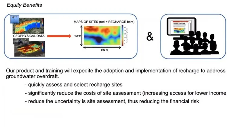
Advanced EM Methods VI. Community Equity Issues
Dr. Knight addresses equity issues in the Central Valley that mostly impact underserved communities that are unable to implement sustainable groundwater management. This is partly due to the prohibitive cost of drilling a well with an appropriate depth. As a result, farmers end up with shallow, inefficient wells. Also, a neighboring deep well drains their shallow wells.
To alleviate some of these challenges, she suggests using the AEM web-based tools to quickly and easily select or reselect recharge sites and reduce the cost of site assessment. In this talk, she briefly describes the web-based analytic tools, and companion Redivis public database for accelerating groundwater recharge in California.
Advancing the Use of Electromagnetic Methods for Groundwater Management in California
Question & Answers:
Click here to read the Questions and Answers.